
Chad Fm
Type Locality and Naming
Bornu Basin of northeastern Nigeria in drill holes. The best section in Niger would be close to Lake Chad. Raeburn et al., 1934.
References: Furon, 1935, 1956; Carter, 1963; Furon, 1964; Faure, 1966; Greigert, 1966; Louis, 1970; Petters, 1981; Wright, 1986, pages 94-95; Ola-Buraimo et al., 2017.
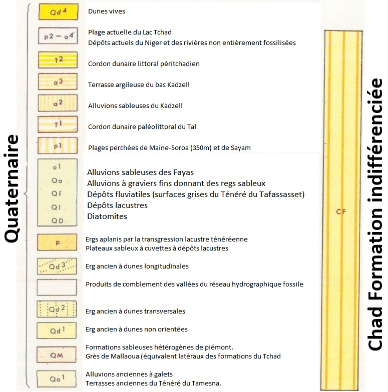
Synonym: “Chad Series” according to Furon (1956). Greigert (1966) calls it "Formations du Tchad". In his 1966 map of the Geology of Niger (appendix A), he includes all the consolidated Quaternary alluvium and deposits of Eastern Niger (undifferentiated) in the Chad Formation (Fig. 1).
[Figure 1: Greigert's (1966) definition of the Chad Formation]
Lithology and Thickness
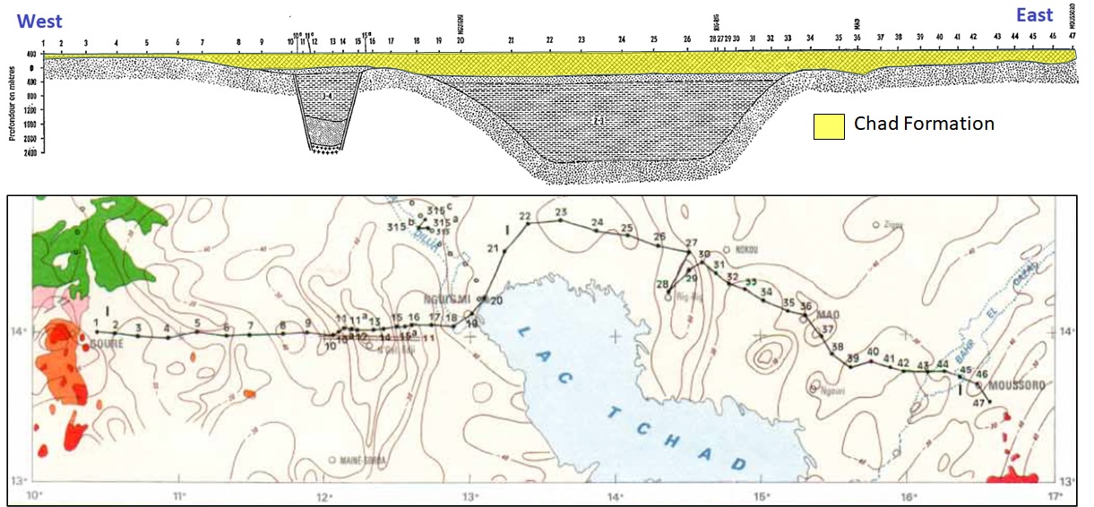
Furon (1956) states that in Nigeria, it is “Green and grey clays and sands with basal feldspathic grits. The formation becomes sandier upwards. Diatomaceous earth occasionally present”. According to Wright (1986), the formation in Niger is composed of Quaternary sands and alluvium (clays and diatomite) that obscure older sediments over all the area occupied by the Eastern Niger Rift basin. According to Adegoke et al. (2014), the formation in Nigeria, just to the south, is made-up of a Quaternary sedimentary sequence of fine to coarse-grained sand and clay. The sand is uncemented with angular and subangular quartz grains of variable color from yellow, brown, and white to grey. At the same time, the clay is massive and locally gritty in texture due to the presence of angular to subangular quartz grains. Its thickness is 600 m in Nigeria. If Louis (1970) is correct, it will reach a thickness of 300 meters in the Ténéré (Niger). This same author provides a seismic profile (Fig. 2) showing a thickness of 400 m for the assumed Chad Formation east, north, and west of Lake Chad (Termit and N’Guel Edji grabens).
[Figure 2: Seismic line and profile showing the assumed Chad Formation east, north, and west of Lake Chad (Louis, 1970)]
Relationships and Distribution
Lower contact
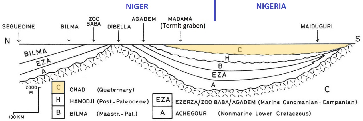
Underlying unit is the Zaouzaoua Fm, Homodji Fm (Fig. 3), Dollé Fm, or Sokor 2 Fm.
[Figure 3: Section showing part of the deposits of the Chad Formation in Niger and Nigeria (Source: Petters, 1981)]
Regional extent
The sediments of the Chad formation were deposited over the area of the former Lake Mega-Chad (Wright, 1986) (Fig. 4 and Fig. 5). The extension of this large lake is confirmed by deposits of laminated diatomites, several meters thick, which are found superimposed on the red sands of the old erg, in the Ténéré, at Fachi, Bilma, Dibella, Agadem, Termit, etc. These diatomites, dated to C14, range between -20,000 and -5,000 years old. They are, therefore, relatively very recent. Petters (1981) extends the formation area to the Téfidet and Tégama/Damergou areas, always within the watershed limits of the East Niger Rift Basin. Louis (1970) also confirms the presence of the formation in the Ténéré region based on seismic as well as in drill holes west of Lake Chad in Niger (Fig. 4 and Fig. 5).
[Figure 4: The Quaternary Lake Mega-Chad as drawn by Faure (1966) in Furon (1964). The numbers written along its contour are dated from archeological sites (-4,900 = 4,900 years ago)]
[Figure 5: The Quaternary Lake Mega-Chad (in pale blue), encompassing areas within Niger, Chad, Cameroon, and Nigeria (Chad Basin), compared to today’s Lake Chad (dark blue) (Source: Bouchette, 2010)]
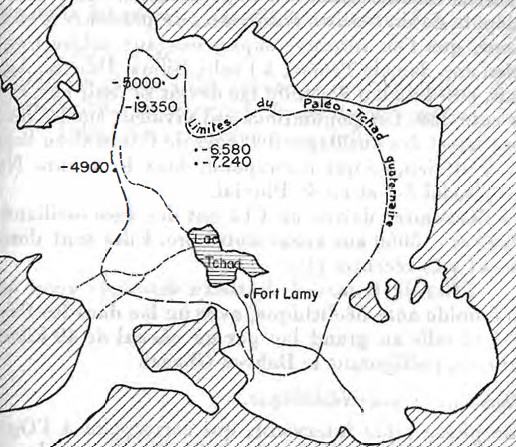
 Fig_5.jpg)
GeoJSON
Fossils
Pleistocene mammals (Hippopotamus imaguncula Hopwood) found at Gubio in Bornu (Nigeria) suggested a Pleistocene age for the surface beds (Furon, 1956).
Age
Depositional setting
Fluvial, lacustrine.
Additional Information